12:45 PM | ***An update on the season’s first tropical threat…an update on the heavy rain/severe thunderstorm threat in the Mid-Atlantic region***
Paul Dorian

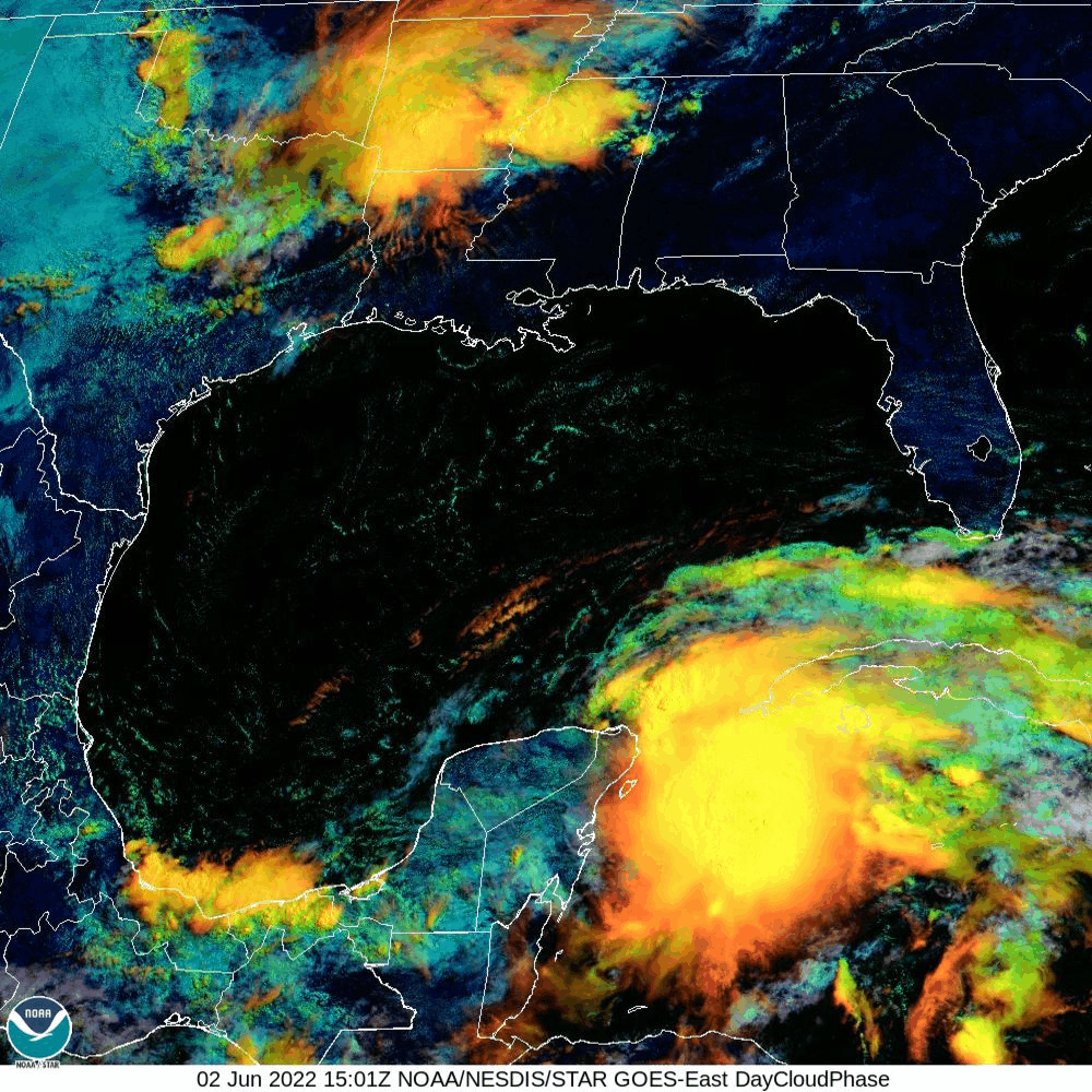
Showers and thunderstorms are becoming better organized today over the northwestern part of Caribbean Sea where sea surface temperatures are quite high. This tropical wave is likely to become the first named tropical storm of the 2022 Atlantic Basin season (would be “Alex”) and is likely to bring a lot of rainfall to western Cuba, much of Florida, and the Bahama Islands. Satellite images courtesy NOAA/NESDIS (day cloud phase)
An early tropical threat
The tropical season in the Atlantic Basin officially got underway on June 1st and indeed there is a growing threat for Florida from a system that is now located over the northwestern Caribbean Sea. An area of showers and thunderstorms has better organized over the last 24 hours or so over the warm waters of the northwest Caribbean as atmospheric conditions have become more and more favorable for intensification. This system is likely to become the first named storm of the 2022 season (“Alex”) and is increasingly likely to bring heavy rainfall to western Cuba, central and southern Florida including the Keys, and to the Bahama Island chain. The timetable for this event is from later tomorrow into the day on Sunday and heavy rainfall amounts of up to a foot or more can result in flash floods this weekend in southern and central Florida…perhaps even northern Florida.

The 12Z GFS forecast track of the tropical system brings it across southern Florida in coming days; however, a slightly farther northward track to central/northern Florida is not off the table. Maps courtesy tropicaltidbits.com, NOAA
Still somewhat unclear is the path that this tropical system will take later in the weekend. One scenario has it tracking into southern Florida (e.g., 12Z GFS) and then over the southwestern Atlantic Ocean. Another possibility is a track towards central/northern Florida which could result in it eventually becoming “tucked in” near the Georgia/South Carolina coastlines at the end of the weekend (e.g., 12Z NAM). This more northward track would enhance the chances of heavy rainfall along those coastal sections of the Southeast US from Sunday into Monday.
For more on the overall outlook for what should be an active tropical season in the Atlantic Basin click here.
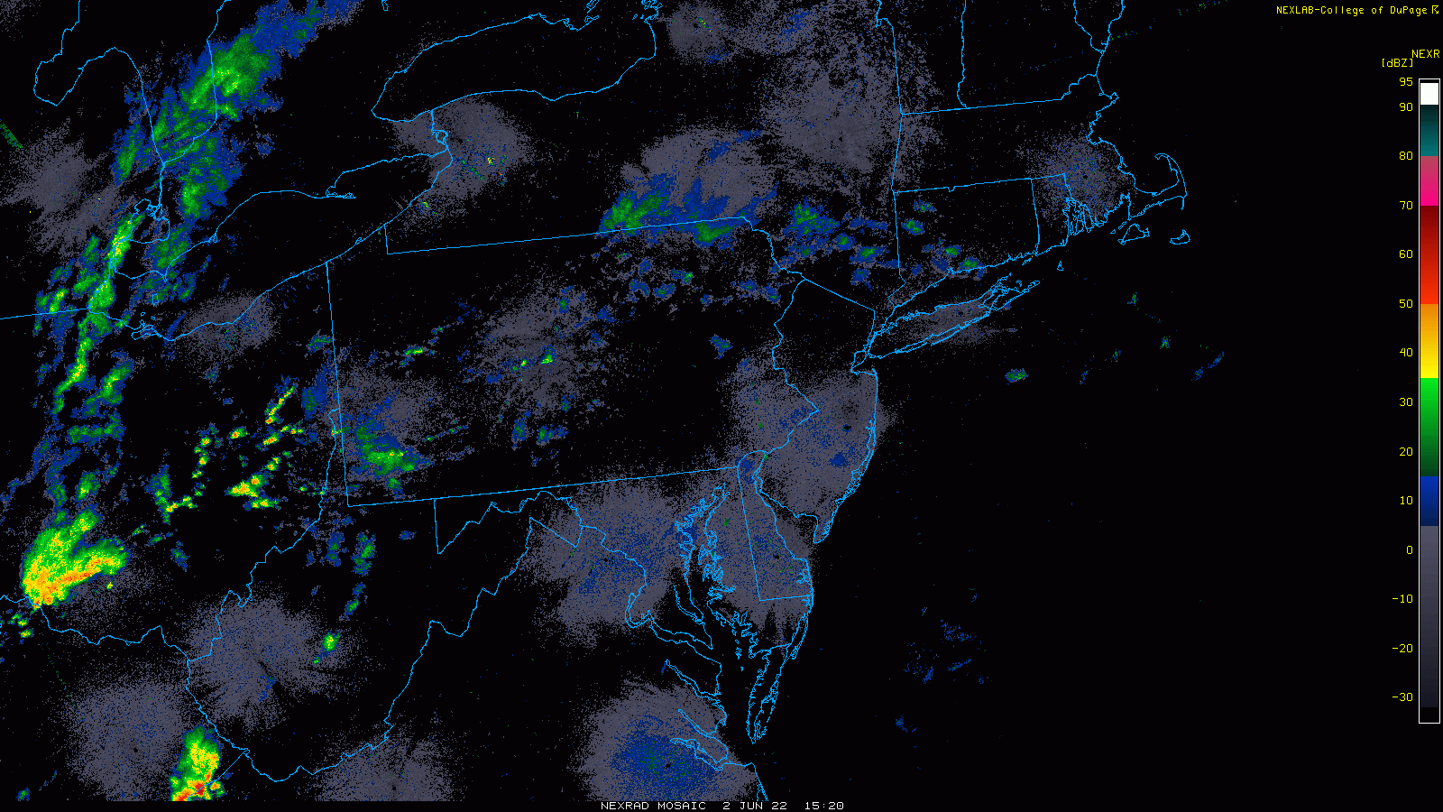
Showers and thunderstorms are building across the western Mid-Atlantic at mid-day and will push to the east over the next few hours. As a result, the threat for severe thunderstorms will increase by the mid and late afternoon hours in the I-95 corridor region from DC-to-Philly-to-NYC. Radar images courtesy College of DuPage, NOAA
Heavy rain/severe thunderstorms in the Mid-Atlantic region
A warm front lifted north through the Mid-Atlantic region this morning leaving the area with warm and humid air at the same time a cold front inches its way in this direction from the west. Low pressure will form along this incoming boundary zone enhancing the chances for heavy showers and possible severe thunderstorms from later this afternoon into early tonight. In addition to the potential of some torrential rainfall, any thunderstorm can produce small hail and damaging wind gusts. Showers and embedded thunderstorms have already formed across western and central PA at the mid-day hour and the overall coverage and intensity will increase dramatically over the next few hours with increased low-level heating. The timetable for the activity in the immediate DC-to-Philly-to-NYC corridor will be rather typical for this time of year i.e., during the warmest time of the day from about mid-afternoon to mid-evening (i.e., 2pm-9pm).
Following the passage of the cold front, high pressure will build eastward on Friday and take back control of the weather in the Mid-Atlantic region. The weekend is shaping up to be very nice with comfortable temperatures and humidity levels on Saturday and Sunday and plenty of sunshine each day.
Meteorologist Paul Dorian
Arcfield
arcfieldweather.com
Follow us on Facebook, Twitter, YouTube
Video discussion: