11:20 AM (Wed) | *****Significant rain and flooding event continues in the Mid-Atlantic…threat of tornadoes will increase markedly later in the day for parts of the area as ”Ida” regains strength*****
Paul Dorian
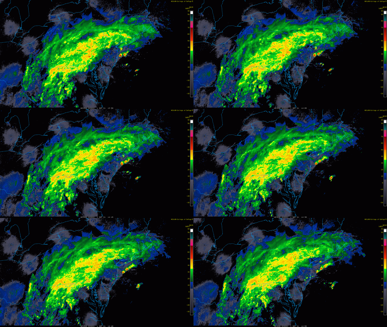
Heavy rain at mid-day extends from western Virginia to southeastern NY. Strong-to-severe thunderstorms are likely to push into the I-95 corridor later this afternoon and points south and east along with the threat of tornadoes. Images courtesy College of DuPage, NOAA
Overview
A significant rain event continues at this time across much of the Mid-Atlantic region associated with the remains of Ida. Flooding has already occurred in some areas as a result of heavy rainfall, strong thunderstorms and already well-saturated grounds. The threat of tornadoes will increase markedly later in the day generally in areas along and to the southeast of the DC-to-Philly-to-Atlantic City corridor. Ida is still classified as a tropical depression and it will likely strengthen some later today as it encounters an upper-level jet streak that is located over the northeastern states.
Tropical Depression Ida will strengthen some later in the day as it encounters an upper-level jet streak over the northeastern states. Image courtesy NOAA/NESDIS
Details
Heavy rain fell in many parts of the Mid-Atlantic region in the overnight hours and continues at this hour in a general southwest-to-northeast fashion from western Virginia to southeastern NY. Flooding has already occurred in parts of this zone particularly in the region extending from south-central PA to some of the northern/western suburbs of Washington, D.C (e.g., Vienna, Rockville). Meanwhile, the rain has shut off in many areas along and to the south and east of Route I-95, but this is a temporary lull in the action and there will be a resumption later in the day - and the threat for tornadoes will increase. The combination of high moisture content and vertical wind shear will raise the chances of tornadic activity later in the day; primarily, in the region extending from DC to central NJ including the Delmarva Peninsula and northward into southeastern PA. Indeed, I would expect to see the National Weather Service issue “tornado watches” early this afternoon in this general part of the Mid-Atlantic region. There is a chance that the sun breaks out in some of this same area that is now experiencing a lull in the rainfall and, if so, this would help to destabilize the atmosphere and increase chances for severe weather later in the day. Any storm that does form during this afternoon/evening can produce a lot of rainfall in a short period of time raising the chances of localized flash flooding in addition to threat of tornadoes.
An upper-level jet streak will help to strengthen Ida as it pushes towards the northern Mid-Atlantic later in the day. Map courtesy NOAA, tropicaltidbits.com
As Ida moves to the northeast over the next few hours and towards the northern Mid-Atlantic, it will encounter upward motion in the atmosphere on the “right rear” side of an upper-level jet that is now located over the Northeast US. This upward motion will allow for Ida to strengthen and, in turn, should result in stronger winds later in the day into tonight along the DC-to-Philly-to-NYC corridor. The rainfall associated with Ida will push into New England in the overnight hours and will wind down for the Mid-Atlantic region by early Thursday. Cool, dry air will follow the departure of this system for the Thursday, Friday, Saturday time period with highs in the Mid-Atlantic generally confined to the 70’s.
Meteorologist Paul Dorian
Peraton
peratonweather.com
Follow us on Facebook, Twitter, YouTube
Video discussion:


