10:55 AM | *Rare noctilucent clouds – the highest clouds seen on Earth – have been unusually prevalent in recent days*
Paul Dorian

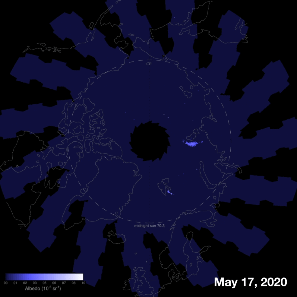
These animated images show NASA’s AIM’s observations from the first week of the Arctic noctilucent cloud season which began on May 17, 2020. AIM is located high above the clouds, taking pictures as it orbits over the poles. The colors — from dark blue to light blue and bright white — indicate the clouds’ albedo, which refers to the amount of light that a surface reflects compared to the total sunlight that falls upon it. Surfaces that have a high albedo are bright and reflect a lot of light and those that don’t reflect much light have a low albedo and appear dark. Credit: NASA/HU/VT/CU-LASP/AIM/Joy Ng
Overview
Noctilucent clouds (NLCs) are the highest clouds on Earth and float near the edge of space in a layer of the mesosphere no more than a few kilometers thick. These unusual clouds are seeded by meteoroids and are quite rarely seen in the US as they are primarily detected in the higher latitudes above +55°N during the late spring or early summer. In 2020, NASA’s Aeronomy of Ice in the Mesosphere (AIM) spacecraft first spotted wisps of noctilucent or “night-shining” clouds over the Arctic region in the latter part of May. In recent days, however, these clouds have been seen in the continental US (Washington, Minnesota) and the growing chill aloft suggests this summer could be as good or maybe even better than last summer when records were set for low-latitude sightings. In fact, temperatures in recent days in the mesosphere layer of the atmosphere have be the lowest since 2007 when NASA’s AIM spacecraft began monitoring noctilucent clouds. Research studies have shown that these clouds tend to be more prevalent during solar minimums and we have been in the midst of one since last year.

"I've been waiting for years to see NLCs, and finally it happened!" reports Phil Halpert from London, England, on June 7th. He noticed their electric-blue ripples over local rooftops then rushed out to photograph them in open sky over Clissold Park (courtesy spaceweather.com)
Discussion
After many decades of study, much remains unknown about noctilucent clouds (NLCs). They are the highest clouds on Earth forming in the mesosphere nearly 50 miles above the ground. These clouds are very cold, filled with ice crystals, float at the edge of space, and they are seeded by meteoroids. They are best viewed at dusk and dawn when the sun is about 6 to 16 degrees below the horizon and when the sunbeams hit those ice crystals, they tend to glow electric-blue. The typical “season” for viewing noctilucent clouds spans from early June through late July and generally in the high-latitude polar regions. In recent days, however, there were noctilucent clouds seen as far south as Washington and Minnesota in the continental US and also across many other mid-latitude locations around the world.

This image illustrates the layers of the Earth's atmosphere. Noctilucent clouds photographed by the crew of the International Space Station are visible in the mesosphere, the layer of the atmosphere between the stratosphere and space. (Courtesy NASA, Weather Channel)
While noctilucent clouds may look like cirrus, they form in a different part of the atmosphere and are best viewed after the sun has dropped below the horizon in the evening or before it rises above the horizon in the morning whereas cirrus are often seen during the daytime hours. Cirrus clouds form in the highest portions of the troposphere, where temperatures can drop to about minus 22 degrees Fahrenheit. At that temperature, enough water vapor is available in the atmosphere to support the development of ice crystals, producing cirrus clouds.

Photograph taken by Andrea Negru on May 31, 2020 in Edinburgh, United Kingdom (courtesy spaceweather.com)
In contrast, noctilucent clouds form in the mesosphere, nearly 50 miles above the Earth's surface. At this height in the atmosphere, so few air molecules exist that it becomes extremely difficult to produce ice crystals. The temperature must drop below minus 207 degrees Fahrenheit for ice crystals to form, and so little water vapor is present that the mesospheric air is a thousand times drier than air from the middle of the Sahara Desert (Source: Weather Channel). In recent days, upper atmosphere temperatures over the middle latitudes have been at their lowest levels since 2007 which is when NASA’s AIM spacecraft began monitoring noctilucent clouds.

There is a visible sunspot today; however, the sun has been spotless 75% of the time in 2020 as solar minimum continues. Image courtesy NASA
Impact of solar minimum on noctilucent clouds
Prior studies have shown evidence of a solar cycle dependence with the appearance of polar mesospheric clouds. One study in particular suggests there is an anticorrelation with noctilucent cloud sightings and solar activity (i.e., the less the solar activity, the more noctilucent clouds become visible). The sun has been blank for 75% of the time this year with no visible sunspots as the solar minimum phase continues as we approach the next solar cycle (#25). During a solar minimum, noctilucent clouds tend to become more prevalent as this period favors the frosting of meteor smoke high above the Earth. Water molecules stick to specks of meteor smoke, gathering into icy clouds that glow electric blue when they are hit by high altitude sunlight. Extreme ultraviolet radiation (EUV) radiation can destroy those water molecules before they freeze. As a result, less EUV during solar minimum can result in more noctilucent clouds.
Meteorologist Paul Dorian
Perspecta, Inc.
perspectaweather.com
Follow us on Facebook, Twitter, YouTube