11:40 AM (Thursday) | ***Major storm to have wide ranging impact on the eastern US next 24 hours including severe weather, heavy rain/flooding and significant snow***
Paul Dorian

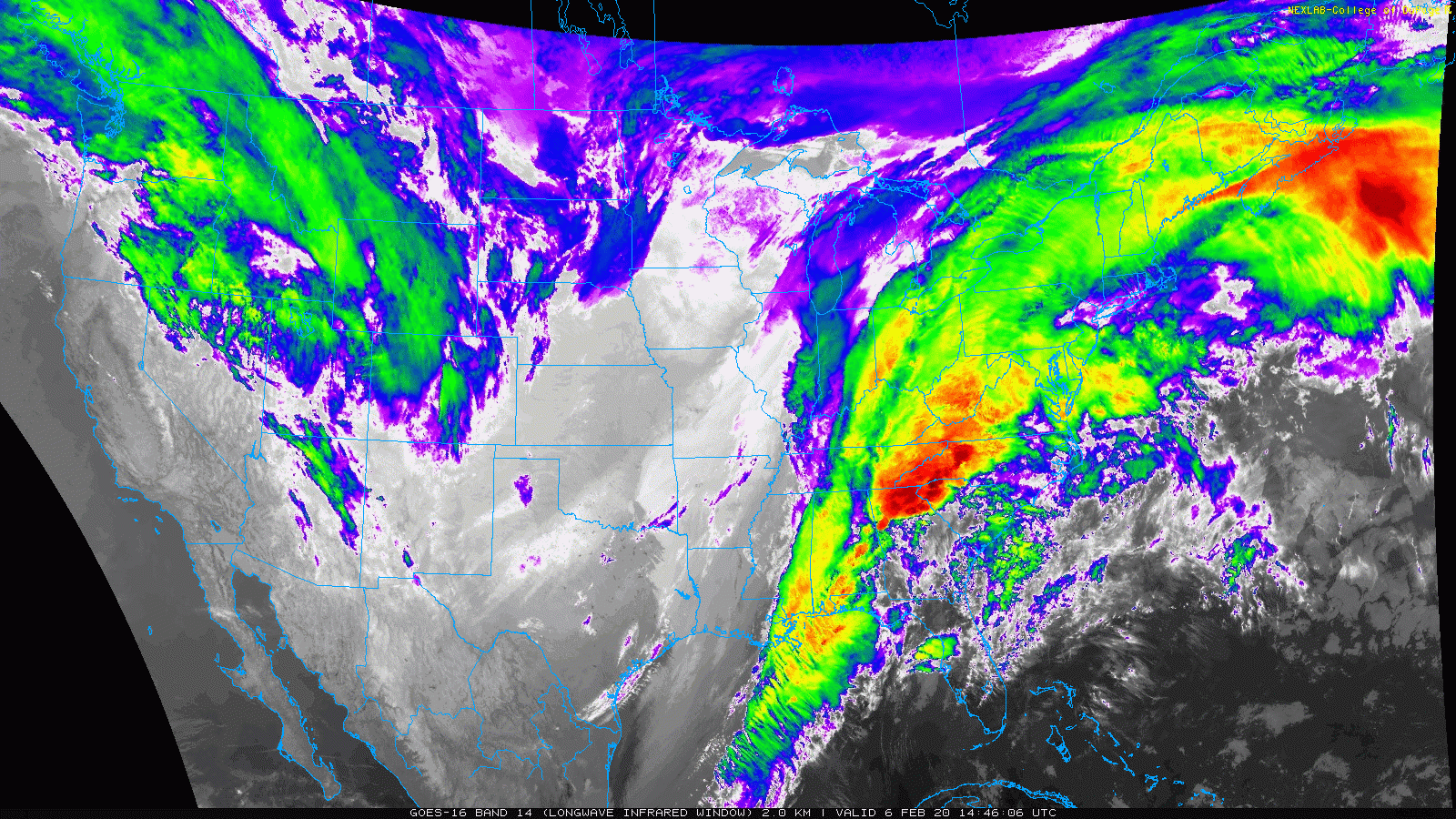
The unfolding storm at mid-day is centered over the Tennessee Valley and is detectable on a loop of longwave IR satellite images; courtesy College of DuPage, NOAA
Overview
Low pressure is now intensifying over the Tennessee Valley and it has tremendous support in the upper part of the atmosphere with a vigorous wave of energy and a powerful jet streak. This developing storm will have a wide ranging impact in the eastern US over the next 24 hours or so with severe weather in the southeastern states, heavy rain/strong thunderstorms and potential flooding in the Mid-Atlantic region, and significant snow across interior sections of the Northeast US.
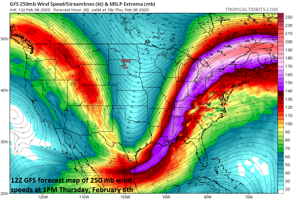
One of the ingredients that will help to generate a powerful storm system is an upper-level jet streak that will produce strong upward motion in the eastern US; map courtesy NOAA, tropicaltidbits.com
Details
A powerful jet streak in the upper part of the atmosphere is combining with a vigorous wave of energy today to produce strong upward motion in the eastern US and this is resulting in an intensifying storm system now centered over the Tennessee Valley. The combination of these upper-atmosphere ingredients with abundant moisture in the lower levels will produce a storm that intensifies dramatically to a central pressure around 968 millibars (28.59 inches) by the time it reaches coastal Maine on Friday evening.
The rain has been scattered and relatively light this morning across the Mid-Atlantic region, but it will become heavier and steadier this afternoon in the corridor from DC-to-Philly-to-NYC. Soaking rain will continue from later today into mid-day Friday in the Mid-Atlantic region and some areas will likely have to deal with flash flooding issues given the already well-saturated grounds; especially, near the coast from New Jersey to the Delmarva Peninsula to eastern Virginia. Temperatures have started off the day at chilly levels in much of the Mid-Atlantic region, but they’ll rebound by later in the day as a warm front pushes to the north and temperatures may actually rise in the overnight hours along the I-95 corridor.

Wide ranging impact expected across the eastern US next 24 hours from an intensifying major storm system as depicted here on NOAA’s “weather warnings” map; courtesy NOAA
On Friday, strong low pressure will move over the interior part of Pennsylvania on its way to eastern New England and a strong cold front will sweep eastward towards the east coast. This frontal passage may be accompanied by strong wind gusts of 50+ mph in the DC-to-Philly-to-NYC corridor and winds will continue to be quite strong from the NW right into late tomorrow night. In addition, there is the threat for strong-to-severe thunderstorm activity on Friday morning and mid-day in the Mid-Atlantic region as the cold frontal whips through the region with potentially damaging wind gusts. There is also a chance for a changeover of rain-to-snow in the northern and western suburbs along I-95 on Friday before the precipitation ends, but, if it were to happen, it would be for a brief time only. A much more significant changeover to snow is likely to occur later tomorrow across northeastern and north-central Pennsylvania where several inches of snow accumulation is possible.
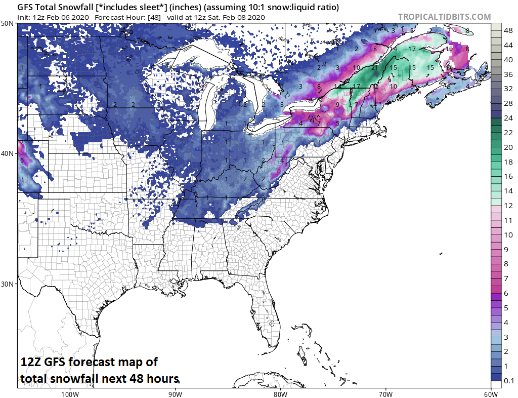
Significant snowfall from this developing major storm system depicted on the 12Z GFS snowfall accumulation forecast map with the heaviest concentration from upstate New York to interior northern New England; map courtesy NOAA, tropicaltidbits.com
Elsewhere, severe weather is likely later today into tonight across much of the Southeast US with damaging wind gusts the primary severe weather threat and there is the likelihood for isolated tornadoes as well. As far as snow is concerned, the favored areas this winter season in the eastern US have been from upstate New York to interior northern New England and this system could very well produce another foot or more in those hard-hit areas by late tomorrow night.
Meteorologist Paul Dorian
Perspecta, Inc.
perspectaweather.com
Follow us on Facebook, Twitter, YouTube
Video discussion: