1:00 PM | *Atlantic Basin tropical activity likely to ramp up next ten days or so after an extended quiet stretch*
Paul Dorian

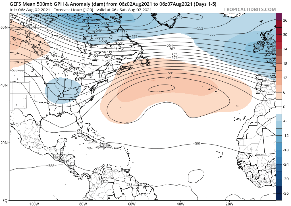
The 500 mb height pattern will evolve into one that will feature strong ridging over the Northeast US and southeastern Canada in coming days…often a signal that tropical systems can push from east-to-west in the central and western Atlantic. Maps courtesy NOAA, tropicaltidbits.com
Overview
The temperature pattern across the US during the month of July was pretty close-to-normal (+1.1 degrees F) and there was an extended quiet stretch in terms of tropical activity in the Atlantic Basin. In fact, there has not been a single named storm in the tropical Atlantic since “Elsa” which came ashore as a tropical storm in northwestern Florida on July 7th. Several signals point to an end to the quiet phase in the Atlantic Basin. In fact, it is not unusual for tropical activity to pick up during the month of August as sea surface temperatures in the Atlantic Basin continue to climb towards their usual early-to-mid September peak. In addition, the unfolding upper-level height pattern across North America will likely become more favorable for a pick up in tropical activity and an increased threat to the US. Specifically, high pressure ridging will build and intensify in coming days over the Northeast US and southeastern part of Canada – often a precursor to tropical activity that can impact the Gulf of Mexico or the east coast of the US.

The current outlook by NOAA’s National Hurricane Center is for “no tropical activity in the Atlantic Basin during the next 48 hours”. The quiet period of recent weeks is likely to change, however, as we progress through the next ten days or so. Map courtesy NOAA/NHC
Sea surface temperatures, MJO, and the 500 millibar height pattern
The 2021 Atlantic Basin tropical season got off to a quick start in terms of the number of named tropical systems, but it has been rather quiet since the first week of July. It looks like activity will quite likely ramp up over the next ten days or so which is not all that unusual for the month of August given the fact that sea surface temperatures generally climb towards their peak typically reached in early-to-mid September. In fact, this year the sea surface temperatures were largely cooler-than-normal about one month ago in the early part of July, but have now reached more normal levels in the early part of August - a favorable signal for increased tropical activity.

The tropical Atlantic Ocean has seen sea surface temperatures climb from below-normal levels one month ago (left) to nearly normal levels today (right, boxed regions) - a bullish sign for increased tropical activity. Maps courtesy Canadian Met Centre
In addition to sea surface temperature patterns, there are a couple of different signals in the atmosphere that point to an increase in tropical activity over the next couple of weeks in the Atlantic Basin. To begin, a teleconnection index known as the Madden-Julian Oscillation (MJO) is headed into an “enhanced” phase that favors increased tropical activity this time of year in the Atlantic Basin.

MJO is headed towards phase 1 and 2 in its counter-clockwise progression according to a recent forecast by the Euro model. Plot courtesy ECMWF, NOAA
The MJO is a tropical disturbance that propagates eastward around the global tropics with a cycle on the order of 30-60 days. It is a large-scale coupling between atmospheric circulation and tropical deep convection (thunderstorms). The movement of the MJO not only has wide ranging impacts on the patterns of precipitation, surface temperatures, and atmospheric circulation in the tropics, but it also influences precipitation and temperature patterns across the globe.

Temperatures for the month of July were pretty close-to-normal across the US (+1.1 degrees) and much of the month was quiet in terms of tropical activity in the Atlantic Basin. Map courtesy “weathermodels.com” (Dr. Ryan Maue, Twitter), PRISM
Typically, when the “enhanced” phase of the MJO pushes into the Gulf of Mexico or the Atlantic Ocean, tropical activity is more favored due to an increase in rising air and thunderstorm development. Not only does the MJO create an increase in precipitation, but studies have shown it also has been known to reduce wind shear across the basin. Wind shear is the change of wind direction or speed with height. Tropical systems do not like wind shear, because if the shear is too strong, it can tear the storm apart.

The storm track of “Elsa” in early July which briefly reached hurricane status off the west coast of Florida before coming ashore on July 7th - the last such named system in the Atlantic Basin. map courtesy Wikipedia, NOAA
In addition to the MJO teleconnection signal, there are signs that the 500 millibar height anomaly pattern will evolve into one that is more favorable for increased tropical activity in the Atlantic Basin. Specifically, it appears that high pressure ridging will build and intensify in coming days over the Northeast US and the southeastern part of Canada. This type of upper-level height pattern is often a “red signal” this time of year for increased “east-to-west” moving tropical systems in the central and western Atlantic which poses a greater threat to the Gulf of Mexico and/or US east coast. Tropical systems that do form with high pressure ridging centered over the NE US and SE Canada can “undercut” the ridge and push westwards towards the Southeast US or Gulf of Mexico…something we’ll likely have to keep an eye on as we progress towards the middle of August.
Meteorologist Paul Dorian
Peraton
peratonweather.com
Follow us on Facebook, Twitter, YouTube
Video discussion: